
Nigerian Inventor and founder of Milsat Technologies Taslim Salaudeen has Digitally Mapped Nigeria Less than 9 Months after inception.
Key Takeaways:
• Young Nigerian Inventor Creates a Startup that Digitally Mapped Nigeria in just 9 Months from inception
• Using native GIS (Geographic Information System) solutions, his invention has developed groundbreaking tools since inception
• His invention digitally mapped the entire country of Nigeria – every building, road, river, and settlement boundary in just nine months, a feat previously considered nearly impossible due to scale, terrain, and connectivity issues
Taslim Salaudeen is the founder of the Nigerian data infrastructure company Milsat he formally established in 2020. Focused on building practical, native GIS (Geographic Information System) solutions, Milsat has since developed groundbreaking tools that address long-standing challenges in location data collection, enabling faster, more accurate mapping even in remote or offline environments.
How Did He Achieve This Huge Feat Rising from Grass-to-Grace in Less than 9 Months?
In the months leading up to the COVID-19 pandemic that would upend the world, Taslim Salaudeen a Nigerian geospatial innovator and technology strategist found himself in a particularly tough spot.
After a string of unsuccessful startup attempts, including Agromini (an agritech venture he launched in 2015) and Upnepa (an energy startup founded in 2017), he began to seriously question whether entrepreneurship still had a place in his future.
For a brief moment, Salaudeen toyed with the idea of completely walking away from the startup world entirely and settling into a more conventional paid job. But instead of giving up, he stepped back and asked himself a deceptively simple question: what did people consistently seek him out for?
The answer was clear—geography. It was the deep understanding of Earth’s landscapes, environments, human settlements, and how people interact with the physical world around them. That moment of clarity became the foundation for Milsat Technologies, the Nigerian data infrastructure company he formally established in 2020. Focused on building practical, native GIS (Geographic Information System) solutions, Milsat has since developed groundbreaking tools that address long-standing challenges in location data collection, enabling faster, more accurate mapping even in remote or offline environments.
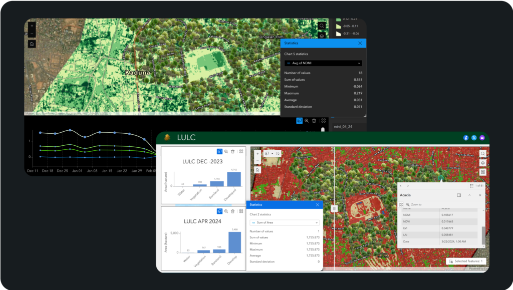
GIS Mapping – Milsat
Key innovations from Milsat include:
– Enumeration Pad: A map-centric mobile data collection tool optimized for Africa. It runs offline on basic smartphones, enables rapid, accurate field enumeration (buildings, roads, infrastructure, settlement boundaries), and syncs when connectivity returns.
– Enumeration Network: A structured force of over 10,000 trained local data collectors who understand accuracy, cultural nuances, and terrain-specific challenges.
– Geospatial Analysis Services: Advanced remote-sensing models and structured pipelines that turn massive datasets into business intelligence thereby helping companies gain competitive edges in planning, market penetration, or risk assessment.
– Geospatial Training Programs: Hands-on curricula that build local capacity from beginner to advanced levels.
Accurate, up-to-date digital maps are essential for modern development. They guide infrastructure planning, disaster response, agriculture, urban management, and even broadband rollout. Yet across Africa and particularly in Nigeria digital mapping faces significant hurdles that slow progress and limit impact.
From vast unmapped rural areas to rapidly growing informal settlements, the continent struggles with outdated or incomplete geospatial data. The good news? Innovative solutions using open data, satellite imagery, AI, and community efforts are emerging to close these gaps.
Key Challenges of Digital Mapping in Nigeria and Africa
- Data Gaps and Outdated Information
Many parts of Africa lack comprehensive, current base maps. Informal settlements can expand overnight, while traditional surveys struggle to keep pace. In Nigeria, fragmented spatial data and reliance on legacy datasets hinder effective planning in sectors like agriculture, forestry, and urban development. - Infrastructure and Connectivity Barriers
Poor internet access, unreliable electricity, and limited broadband in rural areas make data collection, sharing, and updating difficult. High costs of software, hardware, and high-resolution satellite imagery further restrict adoption, especially for smaller organizations and local governments. - Limited Technical Capacity and Talent Retention
There is a shortage of skilled GIS (Geographic Information Systems) and remote sensing professionals. In Nigeria, government neglect, lack of favorable policies, and brain drain have weakened the local geospatial industry over the years. Capacity building remains inconsistent across the continent. - Funding, Policy, and Institutional Issues
Spatial Data Infrastructure (SDI) efforts often face coordination challenges between agencies. Data sharing is limited by privacy concerns, lack of standards, or insufficient policy frameworks. Political instability in some regions and competing priorities also delay large-scale mapping projects. - Rapid Urbanization and Climate Pressures
Africa’s fast-growing cities and vulnerability to floods, droughts, and soil degradation demand frequent updates. Traditional paper-based or slow manual methods cannot match the speed of change, particularly for disaster risk reduction and resource management.
These challenges result in real-world consequences: delayed infrastructure projects, inefficient service delivery, poor disaster preparedness, and missed opportunities for investment.
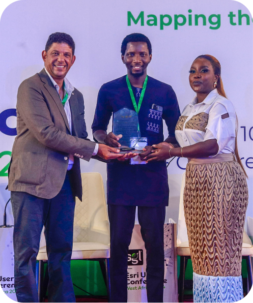
Founder Salaudeen at Globe Awards 2024 – Milsat
Real-World Impact
Using native tools and methodologies, Milsat digitally mapped the entire country of Nigeria – every building, road, river, and settlement boundary in just nine months, a feat previously considered nearly impossible due to scale, terrain, and connectivity issues. Clients typically save 40-70% on fieldwork budgets by leveraging Milsat’s ground-truthed, locally optimized data.
How it works
The Milsat Technologies Approach (Native African Innovation)
Practical, native GIS solutions tailored to real-world African challenges. Founded in Nigeria by geospatial innovator Taslim Salaudeen, Milsat operates as a Data Acquisition as a Service (DaaS/DPaaS) provider. They build location data collection tools, methodologies, and analytical concepts specifically for the African ecosystem integrating popular geospatial platforms while addressing offline realities and local expertise gaps.
Global Innovative Digital Mapping Technologies
- Open Mapping and Community-Driven Efforts
The OpenStreetMap (OSM) community in Nigeria and across Africa is filling critical gaps through volunteer mapping. Initiatives like State of the Map Nigeria and Africa conferences bring together mappers to focus on humanitarian needs, such as mapping displaced communities in Northeast Nigeria. Local youth and communities are trained to collect and validate data, ensuring relevance and ownership. - Satellite Imagery and Digital Earth Africa (DE Africa)
Platforms like Digital Earth Africa provide free, ready-to-use Earth observation data for the entire continent. This helps address challenges in urban mapping, water resources, flood risks, and land cover monitoring. Nigeria has collaborated with DE Africa and NASRDA (National Space Research and Development Agency) to strengthen geospatial capacity for agriculture and disaster response. - GeoAI and Machine Learning
GeoAI-Africa and similar networks are teaching young professionals to use AI for rapid mapping. Tools can extract building footprints, road networks, and flood inundation maps from satellite data in hours instead of months. AI-powered solutions like BEAM (Building and Establishment Automated Mapper) have dramatically sped up informal settlement mapping in cities. - Broadband and Infrastructure Mapping Projects
The Africa-BB-Maps initiative (supported by the ITU and EU) is helping countries including Nigeria build national broadband mapping systems. These platforms integrate infrastructure data to identify connectivity gaps and attract targeted investments. - Public-Private Partnerships and Capacity Building
Organizations like Esri’s Africa GeoPortal, local firms (e.g., Geoinfotech in Nigeria), and international partners offer training, affordable tools, and custom solutions. Drone mapping, mobile GIS apps, and open-source software like QGIS are lowering barriers for users. - Policy and Regional Collaboration
Efforts to develop national Spatial Data Infrastructures, harmonize standards, and promote data sharing are gaining traction. Initiatives focused on digital sovereignty and local data stewardship emphasize African-led solutions.
The Road Ahead for Nigeria and Africa
Nigeria, as Africa’s most populous nation and a major economy, has a pivotal role. Strengthening NASRDA, supporting local OSM communities, investing in GIS education, and integrating geospatial data into national planning (e.g., for Smart Cities or agriculture) could accelerate progress.
At the continental level, scaling platforms like Digital Earth Africa, expanding GeoAI training, and sustaining projects like Africa-BB-Maps will be key. Success depends on:
- Increased government investment and policy support
- More public-private and community partnerships
- Focus on sustainable capacity building rather than short-term projects
- Leveraging affordable technologies like open-source tools and freely available satellite data
Whether you’re a policymaker, business leader, urban planner, or entrepreneur, GIS solutions empower evidence-based decisions by revealing the “where” and “why” behind complex problems. In Nigeria and across Africa, native innovators like Milsat are closing the data gap, proving that geography isn’t just about understanding the Earth it’s about shaping a better future on it.
Disclaimer!
This publication is made for Educational and awareness purposes. The information provided here are based on verified human aided research and studies.


Leave a Reply